| |
Offshore operations along the West African
coast and other areas of the world are regularly impacted by severe thunderstorm
activity. The strong winds from these thunderstorms pose
significant risks to equipment and personnel.
Using radar, offshore operators can only achieve several
minutes warning of approaching thunderstorms. The radar
identifies the precipitation within the storm, but for dry
thunderstorms the radar will be unable to pick up on the
approaching weather. It is also extremely difficult to judge
the speed of approaching thunderstorms by using a radar.
|
| |
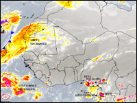
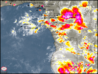
Squall Line Advisory service takes the form of a twice daily email with text
discussion with an attached High Resolution Infrared satellite
image. The
satellite image is then annotated to show key features.
Updates and warnings are issued as frequently as necessary
with attached images.
Our meteorologists constantly monitor
satellite imagery, updated every 30 minutes in most
areas, for your area of concern. Observations are also taken
from local airports to judge the strength of
thunderstorms passing through an area. Once developing
thunderstorm activity is identified, a statement as to
the location of the thunderstorm, the direction of
movement, and anticipated time of arrival is issued.
This unique thunderstorm forecast service can provide in
many cases over 8 hours warning of approaching
thunderstorm activity, allowing operators to take the
necessary avoidance measures
|