|
WilkensNowcasting is now offering forecasts for currents
and eddies based on the tried and tested Colorado University
Princeton Ocean Model (CUPOM) model. In
order to plan your schedule, you need to have access to a
reliable forecast. Data obtained by tracking and monitoring
will continue to feed into and improve the forecasts.
In
the past, eddies have been tracked via satellite during the
fall, winter and spring when water temperatures are cold
enough that the warm eddies can be distinguished from the
cooler Gulf waters. Unfortunately, cloud cover limits use
year-round, and the lack of a thermal contrast limits use in
summer. Satellite altimetry provides observations of the
sea surface height above a frame of reference, but this is
limited by spatial resolution and small eddies can slip
through undetected.
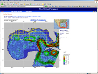
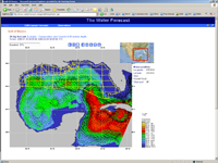
In the lease areas most commonly impacted by the Loop
Current, the CUPOM model correctly estimates the distance
within 10 to 15 miles to the Loop Current in a one- to
four-week forecast, performing admirably in predicting the
movement of the eddy center. To further improve forecasting,
we recently doubled the model's horizontal resolution to
1/24 degree with 24 depth levels and extended the southern
boundary into the southern Caribbean. Model accuracy has
also been improved from previous trials since there are now
five satellites with radar altimeters in operation. No
longer will small eddies easily slide through undetected.
|